
Hurricane Ian hit western Cuba early Tuesday as a Category 3 storm, and its route and strength are unclear as it comes closer to the US mainland. Florida is supposed to stay in the storm’s path, but computer models disagree on whether Ian will land on Florida’s west coast or go more towards the Panhandle.
Residents of coastal communities in the Tampa Bay area have been instructed to evacuate and encouraged to travel even short distances to escape the storm's worst effects.
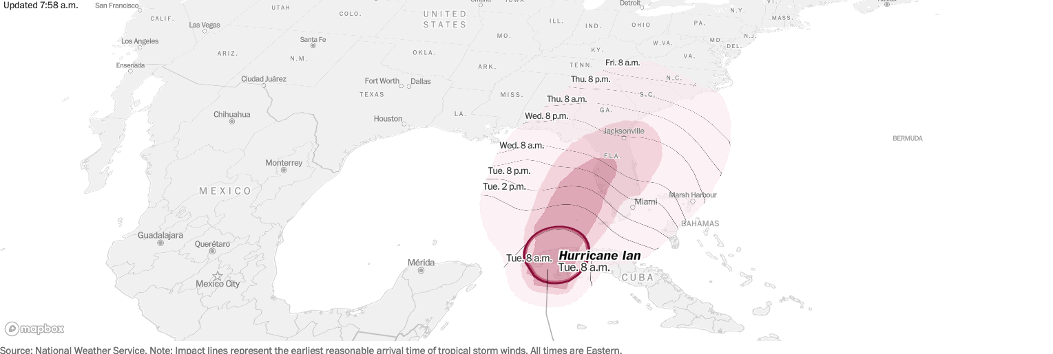
The National Hurricane Center's latest advisory predicted that Ian would enter the Gulf of Mexico in the late morning, pass west of the Florida Keys later Tuesday, and reach the west coast of Florida as a major hurricane by Wednesday night.
The storm intensified to become a Category 3 hurricane overnight, with estimated maximum winds of more than 115 mph at its core before landing near La Coloma in the Pinar Del Rio Province of Cuba. The National Hurricane Center warned that life-threatening storm surges, hurricane-force winds, flash floods, and mudslides could occur in western Cuba overnight and Tuesday, urging residents to evacuate and protect their property quickly.
By 8 a.m. Tuesday, Ian had increased in strength, with 125 mph maximum sustained winds. It was moving north at 12 mph, about 130 miles southwest of Dry Tortugas National Park near the Florida Keys.
“The fact that we’re even in the conversation for possible landfalls is heightening people’s stress of being in the cone of uncertainty,” Thomas said.
Even if Ian makes landfall elsewhere, she added, “it’s still terrifying to be spoken about on the periphery of a storm like that.”
Ian threatens to bring severe flooding and damaging winds to Florida’s Gulf Coast, appearing bound for landfall somewhere between Naples and the west coast’s Big Bend area between Wednesday and Thursday. It is forecast to become a Category 4 storm with 140 mph winds by late Tuesday, making it the strongest September hurricane in the gulf since Rita in 2005. The storm is then expected to weaken slightly as it approaches Florida, striking land as a Category 3 with maximum sustained winds of 125 miles per hour.
The National Hurricane Center issued hurricane warnings across the Tampa Bay region Monday evening, along with storm surge warnings, and extended it southward to Bonita Springs on Tuesday. This is because weather forecasting models were increasingly suggesting Ian would make landfall toward the southern zone of earlier predictions, close to Tampa Bay or even just to its south.
The hurricane’s biggest threat may be the storm surge — a rise in ocean water over normally dry land caused by low air pressure and winds. The National Hurricane Center predicts Ian could send as much as 5 to 10 feet of storm surge onto Florida’s coastline, a hazard that can be deadly and destructive. The gentle slope of the ocean bottom along the Florida coastline means that even a minor hurricane or tropical storm can be capable of causing serious coastal inundation.
The storm’s expected slow movement as it approaches Florida also probably means flooding rains, with 10 to 20 inches or more possible in some areas.
Ian comes as part of a surge of late-season tropical activity in the Atlantic basin where no named tropical cyclones formed during August for the first time in 25 years. While meteorologists had been watching as many as five tropical systems in recent days, including a nascent Ian, the storm is now one of two under surveillance. Several hundred miles west of the Cabo Verde Islands, the other could soon become Tropical Storm Julia.